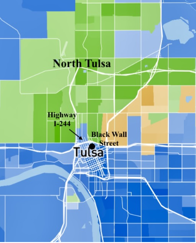
As I have finished collecting my data points for my research on spatial inequalities in North Tulsa, particularly impacting Black Tulsans, I have begun analyzing and making sense of my findings. It was fascinating to watch the resource landscape take shape, as I mapped each institution encountered during my exploration of North Tulsa. Through reflecting on these mapping practices, I have gained a fuller picture and more intimate understanding of the production of inequalities we see in North Tulsa today.
One key lesson I have learned in the mapping process is that it is not just the quantity or spatial placement of resources that can perpetuate enduring inequalities – it is also the quality and level of investment in each resource. This realization has clarified that even when there are sufficient numbers of community institutions providing essential resources, like grocery stores, disparities can persist between North Tulsa and the rest of the city. For example, the diversity of products or services offered at the institutions still might fail to meet the community needs. In other words, the quantity and spatial placement alone cannot fully explain why unequal outcomes are produced in North Tulsa. This is why I have found it crucial to immerse myself in the North Tulsa community, accessing the resources myself, to better understand the potential limitations of the resources I’ve mapped.
This experience this summer has opened up many future avenues of research that can build on the knowledge base my project has produced. While mapping North Tulsa has been valuable to understanding the local and specific needs of this area, specifically in its resource accessibility, there is currently no reference point to serve as an indicator of resource availability in other parts of Tulsa. Mapping the rest of the city’s resource landscape could be essential to making sense of the ways inequality has been preserved in “place” in North Tulsa, allowing for comparisons that might explain how different resource landscapes translate into certain outcomes, whether beneficial or harmful.
As I contextualize my project in the larger movement towards reducing racial inequalities in Tulsa, especially in relation to its history, it is clear that while spatial inequalities can account for many of the disparities in North Tulsa, it continues to only remain a fragment of steps towards repairing the harm done towards Black Tulsan communities. Addressing resource gaps can help build a foundation for meeting the basic needs of North Tulsa, but it cannot fully repair issues of segregation and racial inequality here. There needs to be diligent attention towards advancing homeownership and wealth for Black Tulsans as well, and if my research has taught me anything, even in these often “people-based” solutions the notions of “place” can never be erased to truly address those aspects of inequality. In the future, I hope to build on my research this summer in the many ways I have outlined and help clear an informed path forward in addressing segregation, spatial inequalities, and the historical consequences of the Tulsa Race Massacre in my hometown.